|
April newsletter.pdf Size : 1014.625 Kb Type : pdf |
|
|
May newsletter.pdf Size : 2726.881 Kb Type : pdf |
|
|
June newsletter.pdf Size : 2187.536 Kb Type : pdf |
|
|
July newsletter.pdf Size : 2284.054 Kb Type : pdf |
|
|
September newsletter.pdf Size : 2295.567 Kb Type : pdf |
|
|
October newsletter.pdf Size : 2945.567 Kb Type : pdf |
|
|
December newsletter (1).pdf Size : 3084.578 Kb Type : pdf |
|
|
2021 January newsletter.pdf Size : 2761.463 Kb Type : pdf |
|
|
2021 February newsletter.pdf Size : 3729.315 Kb Type : pdf |
|
|
2021 March newsletter.pdf Size : 3446.694 Kb Type : pdf |
|
|
2021 May newsletter.pdf Size : 2797.516 Kb Type : pdf |
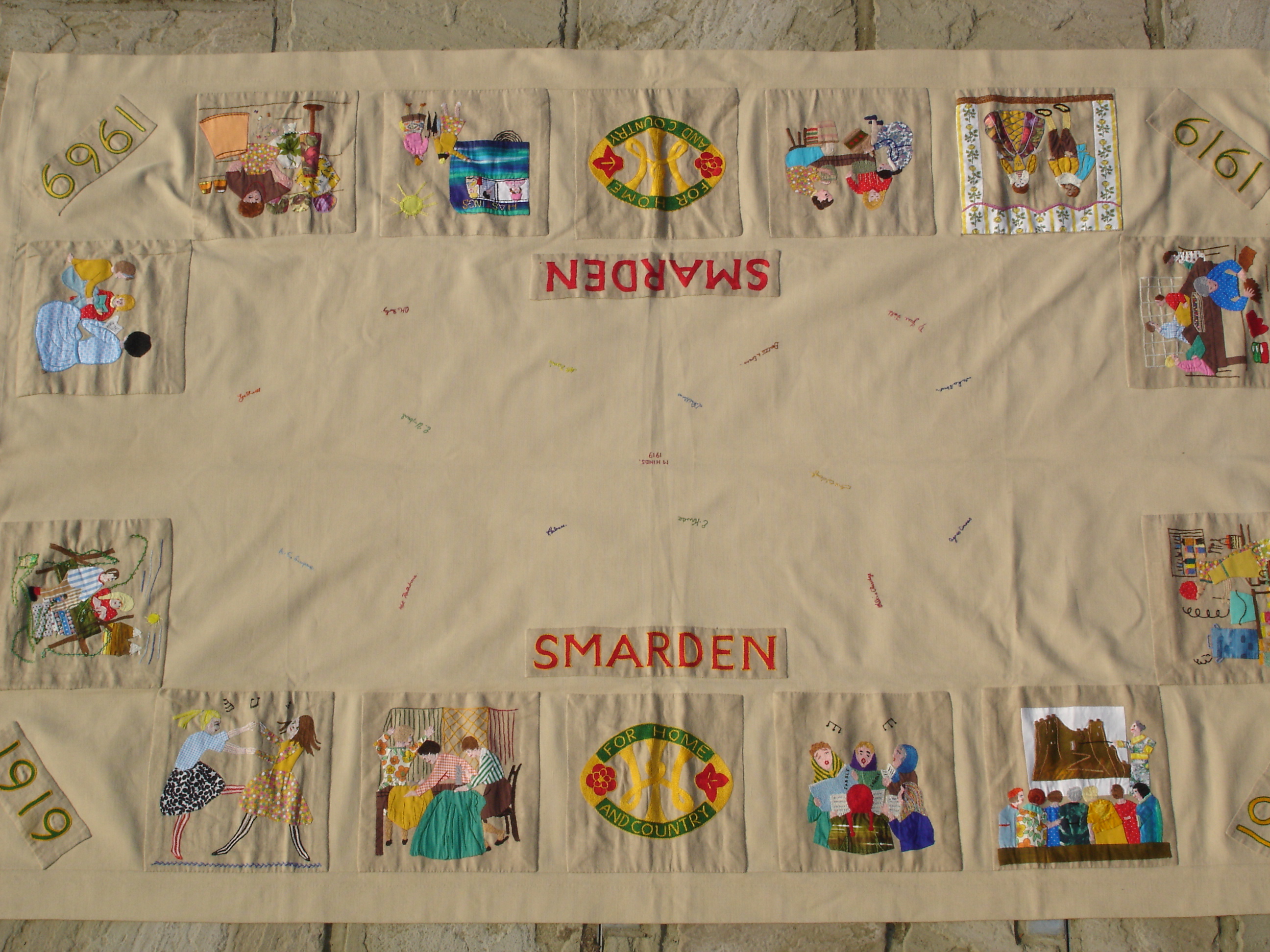
Smarden WI Archive
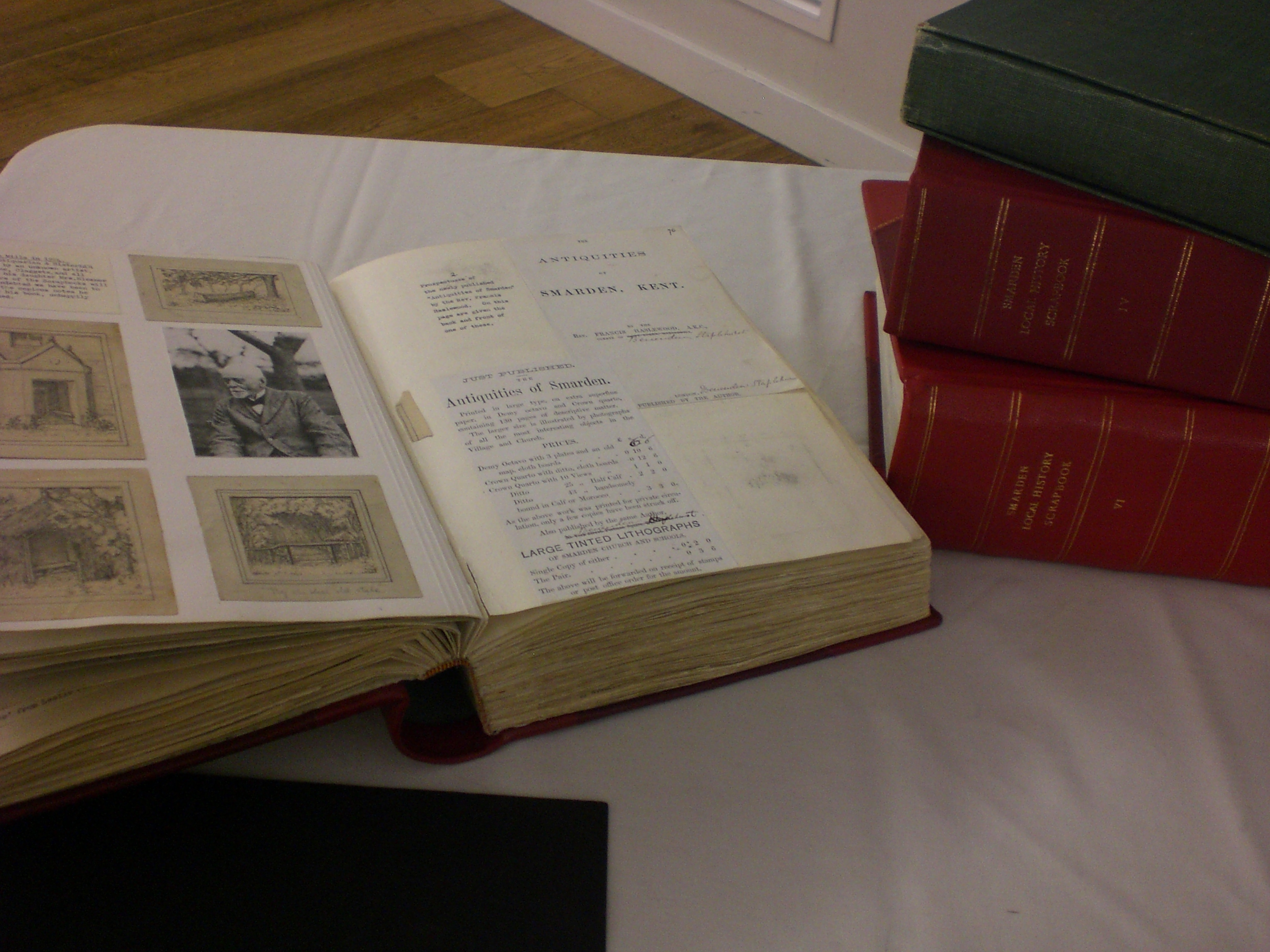
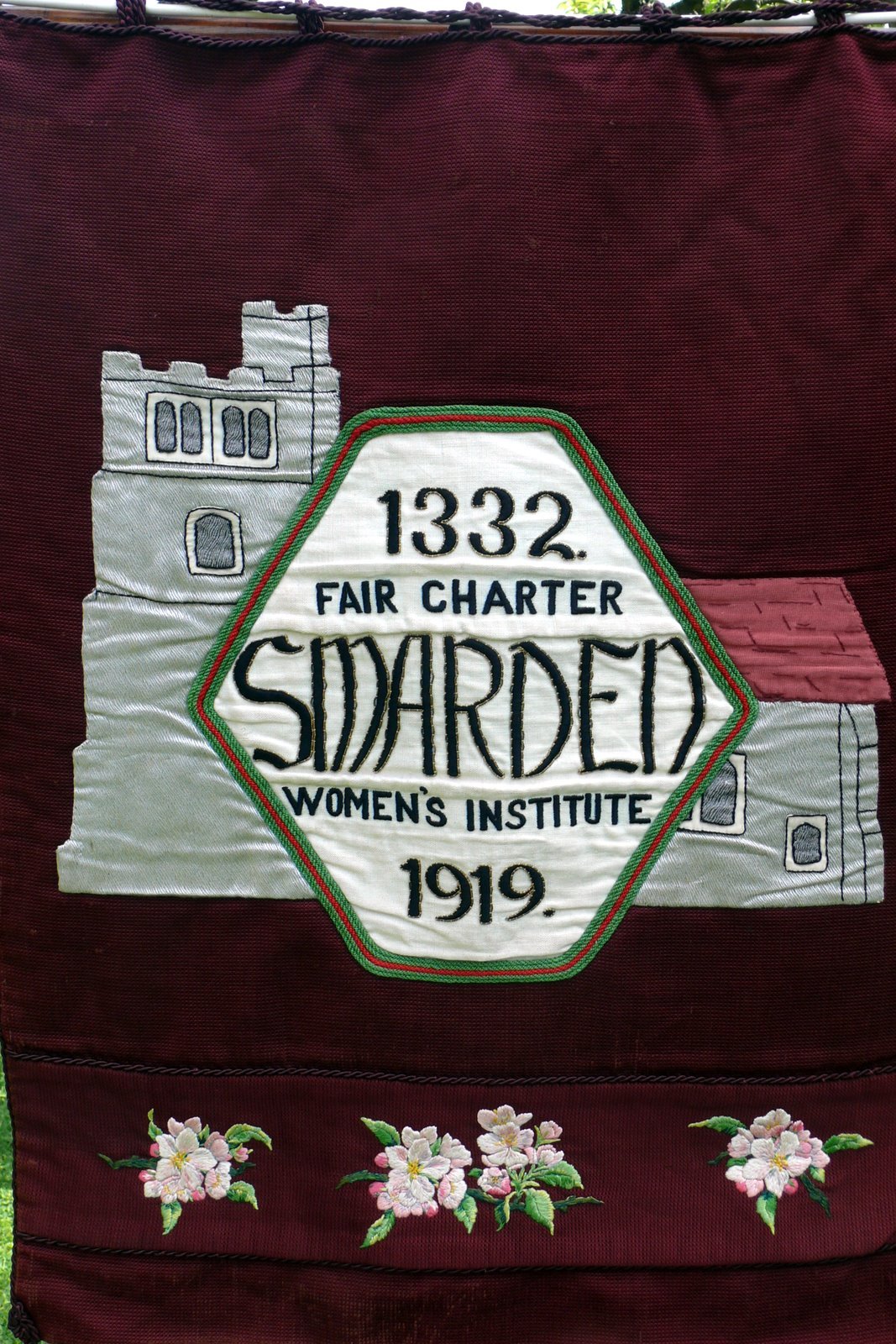
Smarden WI, founded on 17 January 1919, was one of the earliest WIs in the country and we celebrated our 100th anniversary in 2019. Over the years members have created a series of scrapbooks which detail the history of the village and the 6 volumes are a very valuable and fascinating archive.
In addition we are lucky to retain our original banner .
********
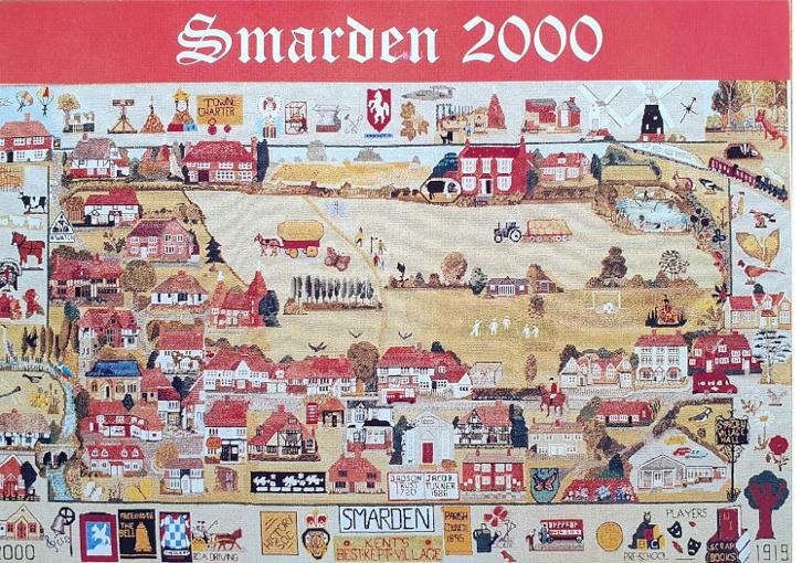
In the Hop Pocket at Smarden Charter Hall hangs the Millennium Tapestry, a magnificent WI creation. It was decided that we would endeavour to portray a street map of the village with a cross-section of houses, public buildings and pastimes of the occupants. The embroidery was mainly created by June Field, Betty Bromley, Eve Phillips and Jeanne Phillips. From concept to completion, the work took 2½ years.
Transcription of Conversation with June Field and Ron Field about the making of The Smarden WI Tapestry
Interview held on Friday 26th November 2010 in Charter Hall
June:
In January 1996 a meeting was called of WI Members interested in marking the turn of the Century by producing a wall-hanging of some sort to place in the Village Hall.
After much discussion it was a greed that an embroidered picture map of the village centre was the most popular idea. Advice was sought from the County Executive and Mrs Ruth Pascoe (who teaches canvas work at Denman College) agreed to meet us and discuss our ideas.
In June we met at Miss Clenaghan’s with a large sheet of paper with a rough outline map of The Street, from the Old Rectory through to The Thatched House and up to and including Mill Lane and
Mrs Pascoe suggested that the ‘picture’ which we proposed ie in total measuring 54” x 3-“ comprising a centre ‘map’ with a 4” border – should be divided into three equal canvases for easier access. Mr Hudson agreed to make three frames approximately 26” x 37”, allowing a good border and material to wrap around the frame secured with drawing pins.
Here I was, proposing a complicated map of the village when I had no experience of design or canvas work!
We purchased the book on the Test Valley Project which has been our “Bible”, showing just how they proceeded and which materials to use. We varied a little on the advice of Mrs Pascoe and it was agreed that we would use canvas fourteen to the inch and Appletons Crewel Wool, mixing three threads together and blending the colours to give the desired effect. We would have to ‘paint with the needle’.
I produced thumbnail pictures of the houses to be included – experimenting until they appeared to be the right size – small enough to get in as many as possible, but big enough to recognise the detail.
We decided to include in the main picture a cross section of houses and places of interest, some old and some newer. It would not be possible to include them all.
Almost all the stitches used would be Tent Stitch (or half a cross stitch) but with back stitching and other stitches in places. The three canvases had to have a half inch border where the joins would be, and spaces at the ends. These three would be joined by back-stitching into every hole, folding back, and the pattern stitched across the join. The border had to be picked out by a longarmed cross-stitch.
The thumbnail sketches were put in place on the map using blutak, and adjusted until we were satisfied. When we were happy with the position, the outline of the pattern was transferred to the canvas using waterproof pen – just the shape of the buildings with windows, doors etc. Photos of the buildings were used to get the details correct, and we were ready to begin.
Betty Bromley and Eve Phillips have been enthusiastic workers with me from the beginning and their help and ideas have been most welcome. We have all had our problems, and taken turns in having to unpick and try again. I have learned a lot from Eve in particular about the stitches, and they have both made beautiful contributions to the whole. Jean Phillips has joined us to embroider the British Legion Badge.
The first stitches were inserted in September 1996. We continued adding detail to the ‘plan’ and the list of places to be included got larger and larger.
Introduction to the Tapestry
An attempt has been made to depict
It is not a photographic likeness and it will be seen as not to scale, but we hope this does not detract from the overall impression.
We apologise to the many people who will see that their houses have not been included, but we have tried to illustrate a cross-section of houses and activities etc.
Let us follow around and explain as we go:
The top border
As can be seen this is the past – history. First one of the private burial grounds to be seen around the
Parish.
Then the Pillory which was, in 1626 in ‘Market Place’. Later moved to the ’Town Barn’.
The market ceased in 1750. Next comes the Martyring of Agnes Snoth in 1556, when she was burned at the stake in Canterbury during the Marian Persecution. In 1333 Edward III granted The Charter allowing Smarden to hold a market. In 1572 Elizabeth I passed through the village and four years later ratified the Charter, granting Town Status to Smarden.
In 1331 the Pell family arrived, and set up weaving in The Dragon House.
The Anvil and tools of the Blacksmith’s trade remind us that there were four Blacksmith’s Forges in and around the village.
Hops were brought to Smarden in 1831 and Arnold Batt was one of the last farmers to grow and harvest them by hand. During World War II work continued in ‘Bomb Alley’ while flying bombs flew overhead.
Next the brickfield in
Smarden had two windmills. The first one shows the West or Post Mill (Cornes’Mill).
The replacement stump can be seen on its original site in the
The second one – the East or Black Mill built in 1804, was worked until 1923. This mill is in approximately the correct situation on the canvas, having been built in
On the corner we have the Smarden Woods or Dering Woods. They were purchased in 1997 by the Woodland Trust and opened to the public.
The Railway which was completed by 1842 for the steam trains, now carries the Eurostar to Brussels and Paris.
Continuing down the right hand side of the border we have Wildlife – animals, birds and flowers of the country-
side.
We will continue in a clockwise fashion, passing The Old Rectory with the Cedar of Lebanon which marks the most easterly point on our ‘map’.
The lower border shows the foundations of village life – the pubs, clubs and societies.
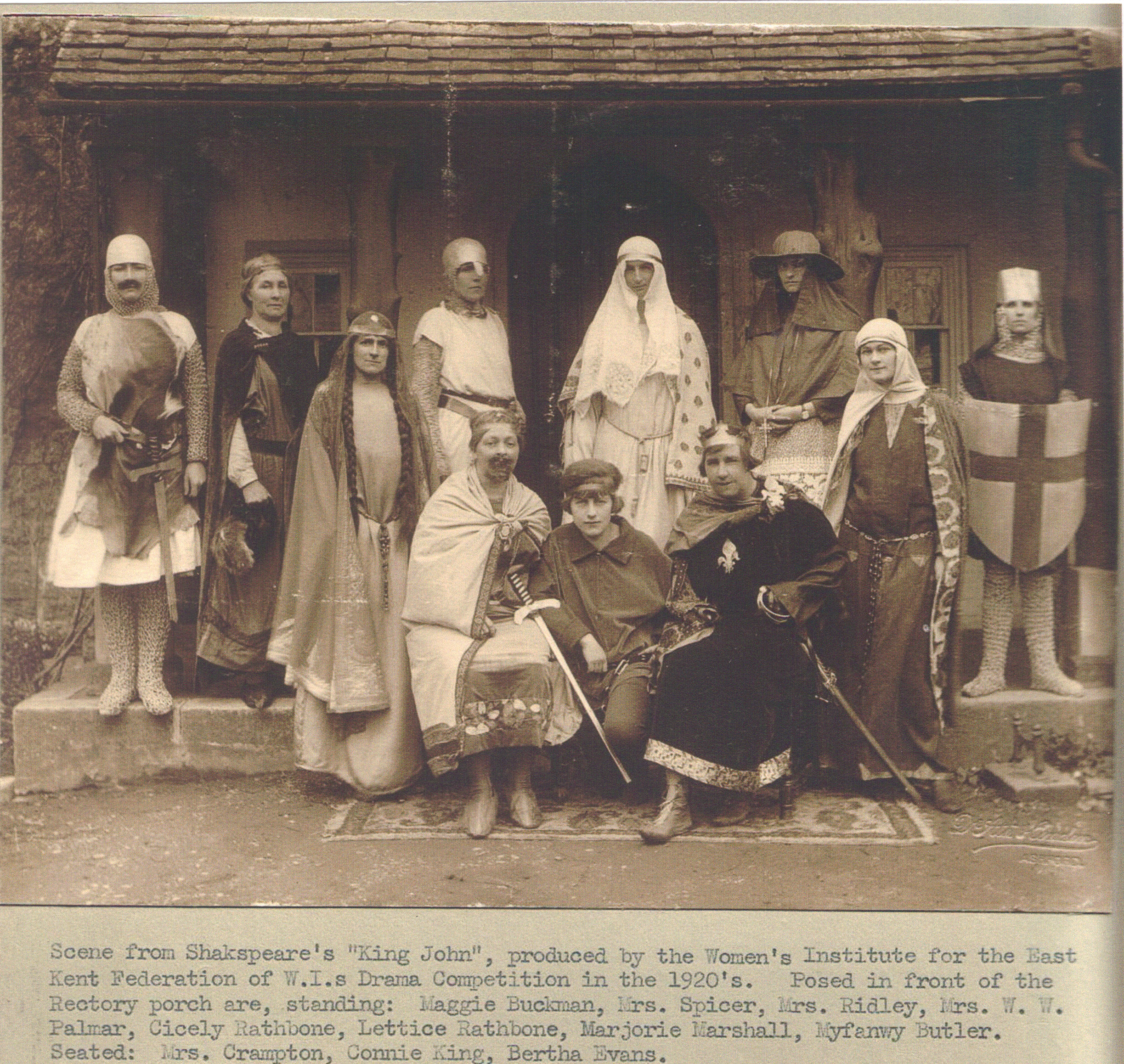
First and foremost the Womens Institute (started in 1919) who are sponsoring the whole project. The badge used is The Tree of Life. We also show the WI Scrapbooks originally edited by a team of members headed by the Rathbone sisters, and continued over the years by an enthusiastic team.
Then come the Smarden Players who put on such professional shows. Next the Pre-School Group and the Brownies, followed by the Over-60’s off on an outing, above which can be seen the Primary School Badge. After this is the Gardeners’ Society.
The Parish Council, and Best Kept Village follow, then the British Legion and History Society.
Riding for the disabled have an enthusiastic group who organise Driving for the Disabled – they can often be seen trotting around the lanes.
Signs are shown for the village’s three Public Houses, the Chequers, the Bell and the Flying Horse ( so named because of the horse-racing which was held on a course in the fields opposite). The Parish Church of St Michael has an active team of Bell Ringers.
The left hand border shows the Bethel and Tilden Chapels situated to the west of the village. The Thatched House is shown, an Elizabethan Cottage next to the River Beult, which is shown with birds and flowers from the waterside. Then come signs of farming: cider apples, strawberries, turkeys, shire horses, sheep and cows, also the rescued lions now cared for at Marley Farm.
The top corner shows The Bell Public House c. 1536, a popular meeting place for the Parachute Club and fliers from Shenley Airfield.
This completes the circle.
Now to the Centre Map… For the purpose of our journey we will enter the village at the East End. The Old Rectory, used for some years as an Old People’s Home, now centres a group of houses known as Hazlewood Close.
Throughout, the estates have been represented by just one house, so first we have
Glebe Close, with the Post Bus in front. Next comes Jubilee House – a unique wooden building in which was held a Ball to celebrate the Jubilee of King George III. Turning down the lane opposite (
Continuing down the main street, on our right we pass the Primary School built of Bethersden marble in 1864, with the Green Lane Estate of houses opposite. These were built in 1948/49.
The young person riding by is a common sight.
Chessenden, a beautiful 15th Century house ( 1470), a Hall House or ’Smoke House’, at one time used as a village Poor House.
The Zion Baptist Chapel built in 1841 ( and used until 1997) is next. The Smarden Baptist Community first started in 1603.
Two charitable trusts are noted here. The first an educational trust, The Dadson Trust formed in 1720, provided money for a Free School, housed in The Street and later transferred to the present school site. The Dadson Trust now provides grants towards Further Education.
The second is The Jacob Turner Trust formed in 1709. Originally it was intended to provide warm winter clothing for the poor of the Parish, and now provides Christmas Vouchers for Senior Citizens.
The Butcher’s Shop is in the centre of a row of weatherboarded houses, and just beyond a lane turning south ends at Vesper Hawk Farm c. 1500.
The Village Pump and Telephone Box come next to The Dragon House (1331), the home of the Pell family who carried out weaving on the premises. The detail below shows the Dragons which decorate the front of the house. They are in fact heraldic Wyverns. Then comes The Post Office - once again in the middle of a row of houses – these leading to the junction of The Street with the Bethersden and Headcorn Roads.
On the North of the main street we go back to the school. The Minnis ( the Village Green). In 1549 it comprised 15 acres owned by The Chantry. It was obtained formally by the village in the 20th Century. It is now the centre of sports and outdoor activities – cricket, and tennis. There is a children’s playground ( not shown). A footpath leads across to
The field beyond the Minnis shows the changing face of farming. In the stubble field, a horse and wagon give way to the tractor and big bales of straw. Men enjoy fishing in the Mill Pond.
Back to the main street and beside the Minnis is The Brothers’ House, formerly known as Thorne House (1480). Swifts fly over the rooftops on summer evenings. The milk float – one of the last tradesmen to deliver goods to customers. After this is The Old School House with cottages which lead on to The Chequers Public House (1550), once a popular resort for smugglers.
Taking the road south, towards Bethersden, we find
We pass The Flying Horse. Opposite is the Beult Meadow Estate with Vesper Cottages next to its entrance. The Town Bridge over the River Beult was built in 1605, formerly known as Church Bridge. Beyond the bridge is The Thatched House (1540) an old Weaver’s Cottage.
Between this road and
Wisteria Cottage can be seen at the bend of
Across the road we find Wagoners, once a wagon lodge, now a comfortable home. Much the same can be said of Gillets Farm Oast House where hops were once dried.
Next comes The Acorns, an estate built on the site of The Oaks, Airey Houses demolished to make room for more permanent homes in 1993 / 94. These are marked by the oak leaf and acorns. After these is the Ashenden Estate built in 1989, a group of ‘Village Houses for Village People’. This was a pioneering project to provide affordable housing for young people of the village.
The local Neighbourhood Watch is marked with a sign along the road.
The most northerly point is The Roundabout, a charming thatched cottage on
The nuts and berries in the hedge complete the ‘picture’ which we now present to you all.
By: June Field. Read in November 2010